“The shear zone is the single, unavoidable obstacle that any traverse outbound from McMurdo contemplating travel on the Ross Ice Shelf must face.” — John Wright, South Pole traverse project manager
The South Pole tra- verse team has started its journey of 1,000 miles and its first step was to cross a crevasse field blocking the way.
The safe road the team built across the treacherous terrain is the first piece of what may someday be a regular surface route from McMurdo Station to the South Pole, freeing up ski-equipped LC-130 airplanes for other missions. Over the next two years the traverse team will go the rest of the way, proving tractors pulling heavily loaded sleds can be a viable way to move fuel and other cargo.
If successful, it will be the first over-snow, heavy-equipment traverse by the U.S. Antarctic Program since 1968, said National Science Foundation Representative Dave Bresnahan, who has been instrumental in developing the traverse route and plans.
“I kind of think we are opening an old book and writing some new chapters,” said Bresnahan.
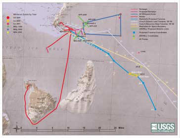
Driving directions to the South Pole are simple on paper – head east from McMurdo then angle across the Ross Ice Shelf; jog up the Leverett Glacier and head due south to the Pole. It’s about 1,000 miles (1,600 km) oneway, a bit longer than the 825 miles (1,320 km) the LC-130 fly, but potentially more reliable and cheaper.
Jeff Scannielo set out markers in early October for the beginning of the intended route, carefully chosen to be the safest, shortest and most fuel-efficient.
Entering the zone
The first 30 miles (48 km) were easy, turning off the Black Island road and heading east to the location that soon became Shear Zone Camp, with a Jamesway and a few tents. The next 3.1 miles (5 km) took two months, as project manager John Wright and a rotating team carefully crossed the shear zone.
“The shear zone is the single, unavoidable obstacle that any traverse outbound from McMurdo contemplating travel on the Ross Ice Shelf must face,” said Wright.
The shear zone is deceiving, “a vast, flat, featureless plain of snow,” Wright wrote in one of his weekly reports. But that seemingly solid ground has swallowed vehicles whole. In 1991, Brian Wheater and Quentin Rhoton were driving a tractor across the shear zone when the snow gave way and the D8 tractor plummeted into a crevasse. They were rescued several hours later,
but the tractor remains buried north of the road Wright’s crew built.
Under the snow, a belt of crevasses runs about 75 miles (120 km) from Minna Bluff to Cape Crozier. The crevasses
occur where the McMurdo Ice Shelf and Ross Ice Shelf meet. The Ross Ice Shelf moves faster than the McMurdo Ice Shelf, so the ice in the four miles between them has one end held back while the other is pushed forward, causing it to angle and crack open in a series of crevasses.
While someone on skis or a snowmobile might make it across the snow bridges hiding the crevasses, making the route safe for an 83,000-lb. (182,600 kg) bulldozer took work. The philosophy was simple, Wright said. Find and fill every crevasse on the route.
“We’re going to take any crevasse head-on and we’re going to gut it and we’re going to fill it and we’re going to cross it,” Wright said.
The route across was selected to meet crevasses at close to a 45-degree angle. It was also one of the narrower points of the shear zone, being three miles (5 km) across, but with the final “miracle mile” nearly crevasse-free.
“It was just like the land of milk and honey if you get there,” Wright said.
Photos courtesy of John Wright and Shaun Norman/Special to The Antarctic Sun
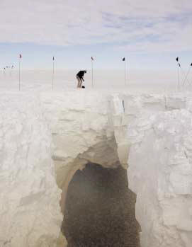
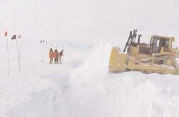
At left, John Wright works on the snow bridge above a crevasse nicknamed Mongo which the South Pole traverse team discovered and blasted open, above right, then filled with snow, as they did all crevasses in their way. At lower right, Kim Uhde pushes snow across crevasse six while Russel Magsig, left, Tom Lyman, center and Shaun Norman, right, watch.
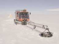
A jeep-sized tracked vehicle, called a Pisten Bully, led the way, scouting the route with ground-penetrating radar 20 feet (6 m) in front of it on a boom. Moving 3 mph (5 kph), the drivers could stop the Pisten Bully within 2 feet of recognizing a crevasse on the screen inside the cab.
Once a crevasse was found, an access hole was opened up for a mountaineer to descend into it on a rope and judge the dimensions.
“It’s pretty amazing, just the expanse of ice you see, the really blue layers,” said Erik Barnes, one of the mountaineers. “It’s a pretty serene environment down there. You are this little tiny speck in the middle of this huge cavern and you look up and you just have one tiny ball of light above you.”
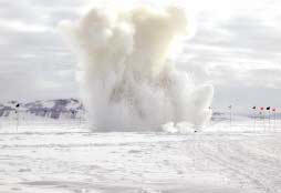
After the mountaineer climbed out, sticks of dynamite were lowered through holes in the snow bridge and the crevasse was blown open. Crossing the shear zone took 5,700 pounds (2,565 kg) of dynamite, Wright said.
The gaping crevasses then had to be filled, which meant finding safe areas to the sides of the route to mine snow.
“That was the hardest part of the job,” Wright said. “You find out there are crevasses everywhere….Our fill-gathering areas were never straightforward. We had to mine snow from fields that looked like kidneys or had islands in them.”
Rich Vaitonis, Brad Johnson and Kim Uhde maneuvered bulldozers through the odd-shaped borrow pits, carrying snow just to the marked edge of the crevasse and dumping it into the hole. They took the biggest risk out there, Wright said.
“They were the cat skinners who built the road across the shear zone. They were the ones who brought the 83,000-lb. piece of equipment up to the edge,” Wright said.
The snow dumped into the crevasse compacted itself, leaving a solid, safe plug for the dozers to smooth over and cross. Each crevasse took one to six hours to fill, depending on its size, plus an hour afterward to prepare the road across.
The team found and filled 32 crevasses, some earning names – Hummer, Strange Brew, Personal Space and Mongo. About five were of a substantial size, the largest about 26 feet wide and 110 feet deep. The large crevasses took about 12,000 cubic yards of snow to fill.
The road they’ve left is a little like a saferoad through a minefield. Step off it and there could be trouble.
“You’d never know there was a crevasse there if there weren’t a sign saying there was a crevasse there, but you damn sure better not get off the road,” Wright said. “The place is full of crevasses.”
The entire shear zone moves north toward the sea at the rate of up to a meter a day, so the road will have moved significantly in a year. Flags mark the road and form a grid around the shear zone road.
“That will tell us how the road is bending or deflecting according to the motion of the shear zone,” Wright said.
Even though the road won’t be in the same place next year, Wright expects it will be basically intact and ready to cross.
Searching out crevasse danger
Driving cross-country in Antarctica depends on being able to find or avoid crevasses before they find you. Many ways have been tried over the years, including a long vehicle the Russians put in front of their traverses.
“Their solution was to use this huge machine that looked like a rocket ship on wheels, the theory being that it’s so long there’s no way it could all fit in a crevasse,” said Steve Arcone, a groundpenetrating radar expert at the U.S. Army Cold Regions Research and Engineering Laboratory in Hanover, N.H. (CRREL).
Early attempts at radar crevasse detection systems were often flawed and could not sense a crevasse until the vehicle or sensor was directly above it, because the radar only saw into the ice directly below it.
Ground-penetrating radar on 20-foot boom in
front of a Pisten Bully warns of crevasses.
When pushed along the ice surface, ground-penetrating radar can see crevasses coming about 65 feet (20 m) ahead of the antenna. It even works from a helicopter, Arcone said, as long as the helicopter stays below about 35 mph (55 kph) and within about 20 feet (6 m) of the surface.
Ground-penetrating radar was originally developed to detect tunnels along the Ho Chi Minh trail during the Vietnam War. Its development and production were then taken over by Geophysical Surveys Systems Inc. in New Hampshire. It became commercially available in 1972 and there are now several manufacturers. Its first use in polar regions was to detect permafrost. In 1975 it was brought to Antarctica. Since 1995 it has been an essential component in developing the South Pole traverse route.
The radar works by sensing reflections from the layers of snow. If the display suddenly shows a gap or more likely a sag in the layers, that’s a crevasse. This has been well known for more than 25 years, said Arcone. What is original in their application is that they exploit the fact that radar waves travel sideways, along the surface, as well as at shallow angles. This allows them to see waves scattered back from a crevasse or snowbridge starting about 65 feet (20 m) away. At 3 to 7 mph, that gives several seconds warning to stop the vehicle.
Though the radar works well, it takes some practice to learn to read. Four members of the South Pole traverse team went to New Hampshire before the season to learn to use the radar, visiting both the manufacturer and CRREL. They used two ground-penetrating radar systems in the shear zone, an area where the McMurdo and Ross ice shelves meet that is riddled with hidden crevasses. The radar detected crevasses along the planned traverse route and in areas alongside the route where bulldozers scooped out snow to fill crevasses.
“We all know that crevasses are dangerous and we all maintained justifiable skepticism (of the radar),” said John Wright, project manager for the traverse. “We were all thinking people and we learned and became proficient and in the end we wouldn’t go anywhere without it.”
Even so, it was tricky to focus and interpret the radar display, and coming exploratory work should include ground penetrating radar experts from the start, Wright said. The crew had been working in the shear zone for two weeks when another radar expert from CRREL, Allan Delaney, arrived and adjusted their radar settings, showing some questionable areas were indeed crevasses.
Because it is on an ice shelf constantly moving toward the sea, the shear zone moves north up to a meter a day, changing as it goes. Glaciologist Tom Lyman rappelled into one of the crevasses and saw signs of an older crevasse aligned in a different direction which had since closed up.
“The ice is constantly swirling around as it moves along,” Arcone said. “It remains to be seen whether radar will be effective in the ensuing years, because we’ve changed these crevasses so much.”
The next step
The crevasses are crossed, but the trip isn’t over, and Wright forged a little farther this season. He and three others continued across the Ross Ice Shelf with a Pisten Bully and Challenger 95 pulling two sleds to see how far they could get in the soft, deep, late-season snow.
“It gives us a good opportunity to see what the snow conditions are like and how the equipment works,” Bresnahan said.
They made it more than 100 miles out, and then back again, in four days without running into any crevasses. That will just be a taste of the year to come.
Next year a larger line-up of tractors and trailers will set out for the Leverett Glacier, the chosen route through the Transantarctic Mountains.
“We think that we’ll run into no crevasses until we run into the Leverett Glacier, but as Hamlet would say ‘That’s a consummation devoutly to be wished,’” Wright said. “That in no way says that you let down your guard.”
Leaving nothing to chance, next year they will bring a bulldozer to fill any crevasses they find, as they will on the initial proof-of-concept traverse the following year.
Climbing from the Ross Ice Shelf up to the polar plateau, an elevation gain of 6,500 to 9840 ft. (2-3 km), is the next challenge for the traverse. After looking at 40 glaciers, the Leverett Glacier was chosen as the easiest access to the plateau, with a steepness of 4 percent or less, firm, dry snow conditions and minimal crevassing. It also has the advantage that heavilyloaded convoys will spend the maximum amount of time first crossing the flat Ross Ice Shelf, becoming lighter as they burn and cache fuel for the return. By the time they have to climb the glacier they will have dropped a significant amount of weight.
In 2004-05 the convoy will go the full distance to the South Pole and back, carrying cargo to demonstrate it can be done.
“The idea is to forge this trail, not a road, but a trail, that may become a snow road in future years,” Wright said.
If the trial-run goes well, supply traverses could become a regular part of the Antarctic program. The NSF plans to evaluate the environmental impact of routine use of the traverse route before the Antarctic program begins regular traverses to resupply South Pole station.
A convoy or “swing” of Challenger 95 tractors pulling full trailers could deliver fuel to the South Pole without using as much fuel as the LC-130s do, according to a report by George Blaisdell at the U.S. Army Cold Regions Research and Engineering Laboratory in Hanover, N.H. (CRREL). The actual supply traverses would consist of three swings, each consisting of six tractors and a mix of 21 sleds and tracked trailers, according to Rick Campbell, a planner for the South Pole traverse.
Of course, it would take longer – 30 days instead of six hours – but fuel and some other cargo doesn’t need to be delivered as quickly as fresh food or people. According to one scenario CRREL recommended, over the course of a season six roundtrip traverses could deliver 243,500 gallons of fuel to the South Pole, about half the station’s needs. The cost of delivery would be from $0.63 to $0.84 a pound, compared to more than $13 per pound by plane from McMurdo, according to the CRREL reports.
But this time cost savings is just a side benefit. The primary reason for the traverse is to make the LC-130s available for other missions, Bresnahan said. During the construction of the new South Pole building, the number of LC-130 flights available to support science around the continent was cut from 150 or more a season to about 70. Some of the planned flights also end up canceled because of weather, which would have less effect on ground traverses.
“Once the route’s established, we can travel in weather we might not be flying in,” Bresnahan said. “Low ceiling is not going to stop the traverse.”
All roads lead to science
Many researchers hope the South Pole cargo traverse will succeed because of the opportunities it would open up. South Pole traverses could replace from 90 to 100 flights, making those LC-130 flights available for science, Bresnahan said. The flights could support research in the deep field or bring more scientific cargo to the South Pole.
“I think the traverse is the greatest thing that ever happened,” said Bob Morse, one of the researchers involved in IceCube, a giant neutrino detector planned for the South Pole. “The traverse could provide a big relief in flights.”
The ability to bring more cargo to the South Pole is critical to the IceCube project, which will need to bring in the equivalent of 280 LC-130 loads of drilling equipment, science instruments and fuel to build the detector. Though the IceCube flights would be spread out over several years, there had been concerns that there wouldn’t be enough flights to go around.
“I hope they manage to get this traverse going, so we’re not sort of taking over all the transport,” said Per Olaf Hulth, a professor of astro-particle physics from Stockholm University who is also part of the new IceCube project.
The traverse itself could also carry scientific instruments to the South Pole that don’t fit through the 10 foot by 10 foot (3 m by 3 m) door of the LC-130.
“It will be a shift in mentality,” said Sridhar Anandakrishnan, from Pennsylvania State University, who was the point person on a paper by the McMurdo Area Users Committee supporting the traverse for scientific reasons. “Right now everybody thinks about what can you do within the confines of the LC-130.”
Science would probably want to tag along on the traverse itself, adding weather stations along the route or observations the drivers could take, Anandakrishnan said. Eventually researchers might use the traverse as a resupply system for summer field camps in the area surrounding the route.
“The sort of geophysical work we do would benefit from having a traverse route along which you know there are regular depots,” Anandakrishnan said. “Having the traverse would allow you to do science along larger areas.”